


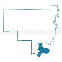
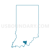
OHIO 02, Crawford County, Indiana
About
Outline

Summary
| Unique Area Identifier | 576727 |
| Name | OHIO 02 |
| County | Crawford County |
| State | Indiana |
| Area (square miles) | 14.09 |
| Land Area (square miles) | 13.46 |
| Water Area (square miles) | 0.62 |
| % of Land Area | 95.56 |
| % of Water Area | 4.44 |
| Latitude of the Internal Point | 38.14280080 |
| Longtitude of the Internal Point | -86.37699910 |
Maps

Graphs
Select a template below for downloading or customizing gragh for OHIO 02, Crawford County, Indiana


Neighbors
Neighoring Voting District (by Name) Neighboring Voting District on the Map
- BOONE, Crawford County, IN
- JENNINGS 01, Crawford County, IN
- JENNINGS 02, Crawford County, IN
- OHIO 01, Crawford County, IN
Top 10 Neighboring County Subdivision (by Population) Neighboring County Subdivision on the Map
- Battletown-Payneville CCD, Meade County, KY (3,460)
- Jennings township, Crawford County, IN (1,436)
- Ohio township, Crawford County, IN (742)
- Boone township, Crawford County, IN (175)